- Þjónusta
- Velferð og fjölskyldan
- Menntun
- Íþróttir og tómstundastarf
- Skipulags- og byggingarmál
- Umhverfismál
- Veitur, hafnir og Þjónustumiðstöð
- Ertu að flytja í Fjallabyggð?
- Stjórnsýsla
- Mannlíf
- Menning og söfn
- Bóka- og héraðsskjalasafn Fjallabyggðar
- Listaverkasafn Fjallabyggðar
- Menningarhúsið Tjarnarborg
- Síldarminjasafnið
- Þjóðlagasetur sr. Bjarna Þorsteinssonar
- Alþýðuhúsið á Siglufirði
- Pálshús Ólafsfirði - Náttúrugripasafn
- Ljóðasetur Íslands
- Saga Fotografica - Photo History Museum
- Herhúsið
- Gallerý og vinnustofur
- Menningarstyrkir
- Bæjarlistamaður
- Ferðaþjónusta
- Upplifðu Fjallabyggð
- Fjallabyggð fagnar þér
- Gisting í Fjallabyggð
- Veitingastaðir
- Afþreying og útivist
- Afþreying utandyra
- Golfvellir
- Gönguleiðir á Tröllaskaga
- 1 - Siglunes
- 2 - Hafnarfjall - Hvanneyrarskál
- 3 - Dalaleið
- 4 - Hestskarð til Héðinsfjarðar
- D-E - Gönguleiðir á snjóflóðagörðum (Ríplum) Siglufjarðar
- 5 - Íllviðrishnjúkur
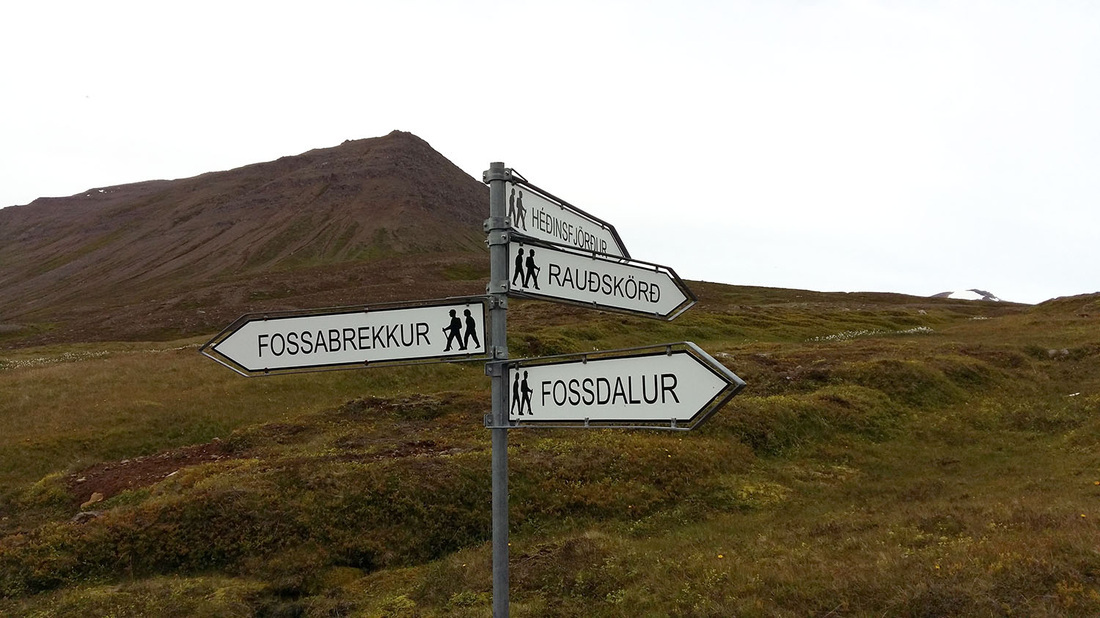
- 7 - Rauðskörð úr Héðinsfirði - Kleifar
- 8 - Fossabrekkur frá Kleifum til Héðinsfjarðar
- 10 - Botnaleið Siglufjörður / Ólafsfjörður
- 11 - Botnaleið - Héðinsfjörður
- 12 - Siglufjarðarskarð
- 16 - Ólafsfjarðarmúli - Múlakolla
- 19 - Grímubrekkur
- 17 - Kerahnjúkur
- 18 - Drangar
- B - Ólafsfjarðarvatn
- C - Gönguleið á snjóflóðagarð ofan Hornbrekku í Ólafsfirði
- Fossdalur
- Hreppsendasúlur
- Hvanndalir
- Reykjaheiði
- Ólafsfjarðarskarð
- Skollaskál
- Sóti Lodge - gönguferðir
- Ferðafélagið Trölli
- Útsýnisflug og þyrluflug
- Vetrarafþreying
- Afþreying á sjó eða vatni
- Sóti Travel
- Skotfélag Ólafsfjarðar
- Náttúrufar og dýralíf
- Gönguleiðakort Fjallabyggðar
- Afþreying utandyra
- Viðburðir
- Áhugaverðar síður
- Norrænir vinabæir Ólafsfjarðar og Siglufjarðar
- Menning og söfn
- Þjónustugátt
- Fundagátt
Gönguleiðir á Tröllaskaga
 Njótið þess að ganga á fjöll og dali í Fjallabyggð.
Margar góðar gönguleiðir eru í Fjallabyggð og flestir ættu að geta fundið leiðir við hæfi. Sumar leiðanna eru troðningar eins og forfeður okkar gengu í 1000 ár, en einnig eru nýrri leiðir sem eru þægilegar göngu og forvitnilegar.
Átak hefur verið gert í merkingum gönguleiða á Tröllaskaga. Einnig má benda á gönguleiðakort sem Hólaskóli hefur útbúið og selt er víða á svæðinu.
Í Fjallabyggð eru nokkur félög sem bjóða upp á vandaðar gönguferðir með leiðsögn.
Göngufólk er hvatt til að nýta heillandi umhverfi Siglufjarðar og Ólafsfjarðar til útivistar og fara með gát, huga að veðri og aðstæðum á þeirri gönguleið sem valin er hverju sinni.
Áður en lagt er af stað í gönguferð eða gönguferð er mikilvægt að leggja mat á reynslu þína, líkamsrækt og búnað til að tryggja örugga og ánægjulega ferð. Ef þú ert byrjandi skaltu íhuga að byrja á auðveldari leiðum og svæðum. Skipuleggðu hæfilega vegalengd fyrir hvern dag og skildu eftir ferðaáætlun hjá einhverjum sem er áreiðanlegur, vertu viss um að uppfæra þá ef áætlanir þínar breytast.
Vertu með GPS, kort og áttavita. Ef þú notar kort án nettengingar í símanum þínum, vertu viss um að þú hafir þegar hlaðið því niður, þú kunnir að nota það og hafðu með hleðslubanka fyrir símann. Þótt gönguleið sé stikuð getur skyggni verið svo slæmt að ekki sést á milli stika.
Margar skemmtilegar gönguleiðir eru í Fjallabyggð sem hafa verið merktar og stikaðar hin síðari ár. Þær eru mislangar og misjafnlega krefjandi svo allir ættu að finna eitthvað við sitt hæfi. Sumar leiðanna eru troðningar eins og forfeður okkar gengu í 1000 ár, en einnig eru nýrri leiðir sem eru þægilegar göngu og forvitnilegar.
Átak hefur verið gert í merkingum gönguleiða á Tröllaskaga. Vert er að benda á gönguleiðakort sem Hólaskóli hefur útbúið og selt er víða á svæðinu., meðal annars á Upplýsingamiðstöðvum í Fjallabyggð.
Nánari upplýsingar og heimildir eru að finna í eftirtöldum ritum:
Siglfirskar þjóðsögur og sagnir, Þ. Ragnar Jónasson.
Siglfirskir söguþættir, Þ. Ragnar Jónasson.
Siglufjarðarfjöll (Árbók Ferðafél. Ísl. 1990) Þ. Ragnar Jónasson
Í strandbyggðum norðan lands og vestan (Árbók Ferðafél. Ísl. 2000) Valgarður Egilsson
Ólafsfjarðarfjöll, Gönguleiðir um Ólafsfjörð og nágrenni, Ferðafélag Íslands og Ferðamálaráð Ólafsfjarðar, 1996.
Ferðalýsing Páls Guðmundssonar FÍ um ferð í Héðinsfjörð og Hvanndali.
Einnig bendum við á Örnefndavefinn http://www.snokur.is/, en það er síða með um 1300 örnefnum á stórum hluta Fjallabyggðar-svæðisins.
Gönguleiðir úr Siglufirði
Almenningshnakki
 Upphaf göngu: Við afleggjarann að Lambanes-Reykjum
Hækkun 880 m (929m yfir sjávarmáli)
Vað: Já/Nei (háð rennsli í Nautadalsá)
Vegalengd: 16 km
Stikuð leið: Já, að hluta, 2 skór
Göngutími: 5-6 klst.
Almenningshnakki er hæsta fjall í fjallahring Siglufjarðar, þaðan er víðsýnt, Héðinsfjörður, Siglufjörður og öll Fljótin blasa vel við. Að hefja þessa göngu Fljótamegin er mun auðveldari leið á fjallið en að ganga Siglufjarðarmegin, hækkun að mestu jöfn og hvergi bratt á fótinn. Gangan hefst við afleggjarann að Lambanes-Reykjum, á sama stað og Botnaleiðin til Siglufjarðar.
GPS: Almenningshnakki.gpx
Siglufjarðarskarð
Vegalengd: 11-12 km
Leið: Skógrækt - Skarðsdalur - Siglufjarðarskarð - Göngudalur - Eggjar - Hraun
Mesta hæð: 620 m
Göngutími 4 - 5 klst.
GPS: siglufjardarskard.gpx
Siglufjarðarskarð (630 m.) er gengið frá Siglufirði eða að vestan frá Heljartröð skammt norðan Hrauna í Fljótum. Um 15 km. leið eftir gömlum akvegi sem búast má við að sé snjóþungur fyrripart sumars. Skammt norðan skarðsins er Illviðrishnjúkur (895 m), annað hæsta fjall við Siglufjörð.
Í Skarðdal, Siglufjarðarmegin, er skíðasvæði Siglfirðinga og neðst í dalnum er nyrsti skógur á Íslandi, skógrækt Siglfirðinga, gróskumikill og fallegur, og mikið notaður til útivistar.
Mjög kvað að illum anda í Skarðinu sem ásótti menn á fyrri tíð svo að leitað var liðsinnis sr. Þorleifs Skaftasonar í Múla árið 1735. Hinn andheiti guðsmaður hlóð þar altari úr grjóti, vígði staðinn og stefndi öllu illu í Afglapaskarð þar litlu austar. Síðan hefur fararheill fylgt flestum þeim sem á annað borð rötuðu rétta leið og gerðu bæn sína við altarið.
Árið 1946 var bílvegur lagður yfir Siglufjarðarskarð. Fram að því höfðu allir meiriháttar flutningar á fólki og varningi farið um sjóveg til og frá Siglufirði. Mikil samgöngubót var að Skarðsveginum þótt fær væri aðeins fáa máuði á ári. Óhöpp eða slys á hinum nýja vegi eru ekki í frásögur færandi. Reynt er að halda leiðinni opinni fyrir jeppa flest sumur.
Distance: 11 - 12 km
Route: Iceland Forest Service - Skarðsdalur Siglufjarðarskarð – Göngudalur – Eggjar - Hraun.Maximum elevation 620 m.
Hiking time in hours: 4-5 hours.
GPS: siglufjardarskard.gpx
From the vantage point above the Iceland Forest Service in Skarðsdalur valley you can still see the traces of the ancient main road that linked Siglufjörður to Skagafjörður fjord and the Fljót area. It is therefore proper to begin the hike over the Skarðið pass from this place. The more easy route to take would be to follow the road but those who are more prone to do steep uphill walking can take a shortcut between the windings and bends in the road. The lowermost windings pass through what is called the Grashólar terrain, when you get further up, the route lays at an angle to the south up the hill over the Þvergil ravine and the Þvergilsöldur dunes directly to the last bend at the bottom of the Skarðdalsvik recess. Many places on this route offer a beautiful view. The road then bends to the north up under the Afglapaskarð pass and Skarðshnjúkur peak and ends in the Siglufjarðarskarð pass. Following this the route goes downhill to Fell, a landslide that divides the upper part of Hraunadalur valley to the north, and the Göngudalur valley. Higher up in the Fell landslide you return to the old mountain trail, which is visible there on the northern edge of the Göngudalur valley. Thereafter you walk downhill following a distinct but rocky path and across over the mouth of the Göngudalur valley and then continue onwards downhill towards Breiðafjall mountain. The front promontory of the mountain is called Selfjall mountain and above it you hike up to the Ytri-Eggjar belt and to the south along the Ytri-Eggjabrekkur slopes. Part of the route the path leads to the bare edge and from there you have a good view over the Innri-Tjarnardalir valleys and the Heljartröð field. An overgrown gully that extends from the edge and down below the main road is called Leignamannalág. This location is where several people from Siglufjörður died from exposure during their trip to the Hólastóll bishopry. There is relatively plenty vegetation there, small birch and berry shrubs and the autumn colours are beautiful, but when you get further to the south you enter the Grjótskálar basin area to your left and then it is only a short distance to the Innri-Eggjabrekka slope and the lower part of the Sauðdalur valley and finally your walk takes you to the south of the Sauðdalsá river down to the main road above the Hraun farm.
Illviðrishnjúkur
 Upphaf göngu: Skíðaskálinn í Skarðsdal
Hækkun: 700 m (895m yfir sjávarmáli)
Vað: Nei
Vegalengd: 3 km
Stikuð leið: Nei, 3 skór
Göngutími: 2-3 klst. (fram og til baka)
Illviðrishnjúkur er næst hæsta fjallið í fjallahring Siglufjarðar, yst frá Strákum, inn fyrir botn fjarðarins og norður á Nesnúp. Almenningshnakki (929m) er hæstur. Tilvalið er aða hefja gönguna frá bílastæðinu við skíðaskálann í Skarðsdal og fylgja fyrst gamla þjóðveginum er liggur um Siglufjarðarskarð. Ágætt er að sveigja af veginum þegar komið er að skíðalyftunum er liggja til vesturs í átt að hnjúknum og fylgja brekkunni þar til efri lyftan endar. Þaðan sést vel á hnjúkinn og Siglufjarðarskarð til suðurs.
GPS: illvidrishnjukur.gpx
Skollaskál og austanverður Siglufjörður
Tími: 5-7 klst.
Vegalengd: 7 - 8 km.
Fyrsti áningarstaður er Álfhóllá Hólsárbakka við flugstöðina. Við hólinn eru bundin forn álög. Álfur útvegsbóndi í Saurbæ, skammt frá, hafði ungur stundað víking og efnast mjög. Hafði hann mælt svo fyrir er hann fann dauðann nálgast að hann yrði heygður í hólnum með skipi og helstu dýrgripum og að engum skyldi gagnast að rjúfa hauginn meðan jaxlar hans væru ófúnir. Sagan segir að ungir menn hafi gert tilraunir til að grafa í Álfhól og ná þaðan djásnum Álfs, en utanaðkomandi atburðir stöðvuðu verk þeirra, t.d. þegar kirkjan á Hvanneyri stóð í ljósum logum og þeir hlupu til aðstoðar. Þegar til kom reyndist kirkjubruninn sjónhverfing. Á Álfhóli er útsýnisskífa með helstu örnefnum í fjallahring Siglufjarðar. Skammt austar, eða um 250 m, eru tóftir Saurbæjar sem fór í eyði á fyrrihluta 20. aldar.
Næsti áningarstaður er Staðarhólsfjara við rústir fyrstu síldarverksmiðju á Íslandi sem reist var árið 1911 og kennd við norska eigendur sína, Evangersbræður. Hin miklu mannvirki, bryggjur, þrær og 5 hús sópuðust burtu í ofboðslegu snjóflóði í aprílmánuði 1919. Níu manns fórust. Geysimikil flóðalda reis upp í sjónum og skall á ströndinni kaupstaðarmegin og olli þar skemmdum á skipum og bryggjum. Býlið að Staðarhóli litlu norðar slapp við snjóflóðið.
Þriðji hluti þessarar göngu er upp í Skollaskál austur af Staðarhóli. Skollaskál er stórgrýtt og gróðurlítil. Kalt og tært vatn sprettur undan grjóturð og rennur hægt milli mosagróinna mela. Hnjúkarnir háu sem hleypa af stað snjóflóðum flesta vetur gnæfa þar yfir. Staðarhólshnjúkur (760 m) og Hestskarðshnjúkur (855 m). Frábært útsýni er yfir Siglufjörð úr Skollaskál.
Þess má sjá glögg merki að mikið framhlaup varð sunnan við Skollaskál í febrúar 1830. Grjót og jarðvegur steyptist yfir bæinn Ráeyri. Íbúarnir hlupu undan og björguðust nema gömul kona sem sneri við til að sækja kisu sína og varð undir skriðunni.
Þægilegt getur verið að að láta undan síga suður og niður úr skálinni og ganga suður í Skútudal áður en haldið er heimleiðis.Yfir Skútudal í suðri rís hin mikilfenglega Hólshyrna Álfhyrna 687 m), eftirlætisfjall flestra Siglfirðinga. Úr Skútudal(5) framarlega er heitu vatni dælt úr jörðu til neyslu og húshitunar í kaupstaðnum. Hitaveitumannvirkin eru sérstaklega hönnuð og byggð til að þola hin öflugustu snjóflóð Þar geta ferðamenn áð á sumardegi og fengið heitt vatn úr krana útivið og hellt sér uppá drykk.
Skarðsdalur - Hafnarfjall - Hvanneyrarskál
Tími: 5-7 klst.
Vegalengd: 13 km
Leið: Skarðsdalur - Skjaldarbringur - Leirdalir - Hafnarfjall - Hvanneyrarhyrna - Strákar - Hvanneyrarskál
Hækkun: 687
Göngutími: 5-7 klst
Gangan hefst við stiku hjá efstu og nyrstu vegarbeygju í Skarðsdal. Gengið er eftir stikum þvert á allbratta hlíð norður á Grashólabrúnir uns sést niður á Dalaskarð. Hægt er að taka örstuttan krók austur á Snók með góðu útsýni yfir Siglufjörð. Merkt gönguleið liggur niður á Skjaldarbringur og skarast við leiðina vestur á Dali. Við Styrbjarnardys sveigir leiðin norðaustur upp á Hafnarfjall með góðri sýn yfir fjörðinn. Þar er varasamt hengiug niður snarbratta kletta ofan Jörundarskálar. Gengnar eru melbungur og má fara skemmri leið niður í sunnanverða Fíadali og áfram á Stórabola, snjóóðaleiðigarð við suðurhluta kaupstaðarins. Þessi leið um 3,5 km er öll stikuð. Hægt er að halda áfram norður Hafnarfjall og vestan Hafnarhyrnu en upp á hana er vel fært vönu fjallafólki og sést þar í hálft hundrað nafngreindra hnjúka, tinda og hyrna. Greið og stikuð leið liggur að nokkru tilbaka niður í norðvestanverðan botn Hvanneyrarskálar og fram á skálarbrún ofan kaupstaðarins.
Distance: approx. 13 kilometres
Route: Skarðsdalur - Skjaldarbringur - Leirdalir – Hafnarfjall – Hvanneyrarhyrna – Strákar – Hvanneyrarskál
Maximum elevation 687 m.
Hiking time in hours: 5-7 hours.
The hike begins at the marker post on the uppermost road bend and furthest to the north in Skarðsdalur valley. You then hike from post to post across a rather steep hillside north of Grashólabrúnir ridge until you have a view down to the Dalaskarð pass. It is possible to take a very short detour east to Snókur where you get a good view over the town of Siglufjörður. A marked hiking trail leads down to the Skjaldarbringur area and overlaps the route west to the Dalir region. At the Styrbjarnardys cairn the trail curves northeast up to the Hafnarfjall mountain, where there is a good view over the fjord. At that place, there is a treacherous precipice beneath which there are very steep cliffs above the Jörundarskálar basin. The hike takes you over an uneven gravel area and it is possible to take a shorter route down to the southern part of Fífladalir hollows and continue to the Stóriboli snow avalanche earthworks, which are located at the southern part of the town. This trail is approximately 3.5 km long with marker posts along the route. It is possible to continue the walk north along Hafnarfjall mountain and west of Hafnarhyrna mountain and the hike up the mountain is easily doable for all experienced mountaineers. An easy path marked with posts leads back down towards the north-westerly bottom of the Hvanneyrarskál basin and to the basin rim above the town.
Dalaskarð - Úlfsdalir
Tími: 3 - 6 klst.
Um Dalaskarð (520 m) til Úlfsdala. Um Úlfsdali liggur þjóðvegurinn til Siglufjarðar. Þar nam Úlfur víkingur land og bjó á Dalabæ. Hann var heygður í hóli niður undir árbakka þar sem hann fylgist með siglingum skipa nú sem fyrr. Helstu fjöll eru Mánárhyrna í norðvestri og Dalaseti (540 m) að austan fyrir miðjum dal rís hinn mikilfenglegi Illviðrishnjúkur (895 m).
Fram yfir miðja öldina var búið á þremur bæjum á Dölum, Máná, Dalabæ og Engidal. Í aldarbyrjun bjuggu allt að 45 manns á Dalabæjunum.
Skömmu áður en komið er að Sauðanesvita, skerst dalverpi, Engidalur, inn milli brattra fjalla. Þar féll mikið snjóflóð á bæinn Engidal árið 1919 og fórst allt heimilisfólkið, 7 manns. Minnisvarði um þennan atburð, hár steindrangur, stendur á bæjarhlaðinu við veginn. Þar skammt frá er Ódáinsakur þar sem vaxa sérstök lífgrös.
GPS: dalaleid.gpx
Kálfsdalur - Nesdalur - Siglunes
Tími: 10 - 14 klst.
Vegalengd: um 20 km.
Gengið út Staðarhólsströnd framhjá rústum Evangersverksmiðjunnar. Upp af Selvíkurvita í austri opnast lítill dalur, Kálfsdalursem leiðin liggur um, með Kálfsvatni og austur yfir Kálfsskarð (450 m). Þá er komið ofan í Nesdal (Reyðarárdal 6 km).
Reyðará er eyðibýli norður á sjávarbökkum. Sagan segir að í fyrndinni hafi Reyðarárbóndi komið af sjó og fundið bæinn brotinn og konu sína og börn látin og limlest eftir hvítabjörn. Rann á bónda æði, elti slóð dýrsins og fann það austur í Hesti (Hestfjalli 586 m). Bangsi forðaði sér og slapp naumlega undan broddstaf bónda með því að stinga sér niður snarbratta gjá sem síðan heitir Bangsagjá. Lengst af var Reyðará í eyði en um 1940 hófu ung hjón þar nútímalegan búskap með góðum húsakosti og miklum jarðabótum. En hinn síbreytilegi "nútími" bauð ekki upp á langvarandi sælu þessa duglega og bjartsýna fólks þarna. Fjörutíu ár sem var þó lengra en á sumum öðrum afskekktum stöðum á landi okkar.
Nú liggur leiðin til vesturs undir bröttum hlíðum Nesnúps (595 m). Þar verður fyrir Siglunesviti sem byggður var 1908 og er einn af elstu vitum landsins. Þar skammt frá má greina ummerki mikilla búða amerísks herliðs sem rak þar radarstöð í seinni heimstyrjöldinni 1943-1945. Miklu var kostað til að fylgjast með þýskum óvinaflugvélum en fátt bar til tíðinda. Eftir stendur amerískur arinn á íslenskum berangri.
Þar með erum við komin á Siglunes þann merka stað. Á seinni hluta 19. aldar bjuggu á Siglunesi um 50 manns, árið 1955 var búið á 6 býlum en síðustu ábúendur fluttu þaðan til Siglufjarðar 1988. Nokkrar deilur höfðu þá staðið um skeið á Siglufirði um hvort leyfa ætti vegargerð yfir hinar illræmdu Nesskriður svo skreppa mætti þangað á jafn skjótan hátt og séra Ásmundur Gunnlaugsson á Hvanneyri (1820-25) gerði á hesti sínum Hreindýrs-Rauð.
Fót nam hvessa fílefldur,
frægðar essi reið ég,
nógu hress yfir Nesskriður,
nú af þessu veit margur.
Þetta orti Ásmundur eftir voðareið sína á hinum undarlega hesti sem var mjög mjósleginn, tagl og fax nær ekkert, sterturinn sem stuttur dindill, fætur háir og grannvaxnir, hófar klofnir líkir klaufum, en vöðvar og sinar hart og stælt sem tré. Ekki verður séð að Siglunesskriður verði gerðar bílfærar í bráð og eru því jafnerfiðar og hættulegar yfirferðar og fyrrum.
Okkur eru nokkrar leiðir færar frá Siglunesi. Sú þægilegasta er sjóleiðin. Önnur er sami vegur til baka og sú þriðja og líklegast sú varasamasta er um Nesskriður. Gengnar eru tæpar kindagötur ofan sjávarkletta. Og nú þarf góða skó og fiman fót.
Mjög óáreiðanleg saga segir að fimmtíu manns hafi farist í snjóflóði nyrst í Nesskriðum á leið til kirkju á sjálfri jólanótt árið 1613. Þótt þessi sögn sé allvíða skráð nú í seinni tíð þá finnast engar haldbærar samtímaheimildir um atburðinn og því talinn uppspuni einn, kannski uppdiktuð sem áróður fyrir því að flytja kirkjuna frá Siglunesi inn í Siglufjörð.
Þegar komið er á Helluhrygg syðst í Nesskriðum verður leiðin aftur greiðfærari. Í Kambalágum neðan Kálfsdals lokast gönguhringur okkar. Þó eru enn a.m.k. 3 km. ófarnir eftir Staðarhólsströnd áður en þessari gönguleið lýkur.
Hvanndalir úr Héðinsfirði
Vegalengd: 6-7 km
Leið: Vík - Víkurhólar - Víkurbyrða - Vestaravik - Hvanndalir.
Mesta hæð: 800 m
Göngutími 4 – 5 klst.
Hvanndalir, eitt afskekktasta byggða ból á Íslandi um aldir, eru norðaustan Héðinsfjarðar, handan Víkurbyrðu (890 m). Til að komast þangað þarf að fara "yfir Byrðuna" eða um Hvanndalaskriður, hinn versta veg. Hvanndalir voru nýttir vegna góðra landkosta fyrir sauðfé, en búseta var þar stopul. Þar hefur margt fátækt almúgafólk leitað frelsis og sjálfstæðis en orðið að flýja þennan harðbýla stað. Skömmu fyrir aldamótin 1900 keypti hreppsnefnd Hvanneyrarhrepps jörðina að Hvanndölum gagngert til að koma í veg fyrir að mannabyggð héldist þar lengur.
Sýrdalur er lítið dalverpi austur undir Hvanndalabjargi (740 m). Ódáinsakur er sagður hafa verið bújörð í Sýrdal fyrr á öldum. Þar vaxa sérstök lífgrös sem eru þeirrar náttúru að þau veita mönnum líf og heilsu. Sagan segir að fyrrum hafi svo rammt kveðið að þessari náttúru að bærinn hafi verið fluttur að Hvanndölum því enginn hafi getað dáið á Ódáinsakri.
"Há eru og hrikaleg Hvanndalabjörg, þar eiga bergtröllin heimkynni og hörg", orti Jón Trausti. Hvanndalabjarg er við mynni Ólafsfjarðar að vestanverðu, eitt hæsta og ógurlegasta bjarg á Íslandi. Bóndakona í Málmey á Skagafirði sem brotið hafði þau álög að enginn mætti búa á eynni lengur en nítján ár, var numin brott af tröllskessunum í Hvanndalabjargi. Hálfdán Einarsson, prestur í Felli sem setið hafði í Svartaskóla samtíða Sæmundi fróða, flutti Málmeyjarbónda sjóleiðis á hesti sínum að Hvanndalabjargi. Þar var fyrir bóndakonan "krossi vígð, komin í bland við tröllin" og varð hún ekki þaðan tekin.
Gönguferðin hefst frá eyðibýlinu Vík í Héðinsfirði og gengið norður um Víkurhóla í mynni Víkurdals. Í norðaustri gnæfir yfir Víkurbyrða. Upp Byrðuna er best að ganga eftir öxlinni þar sem mætast suðvestur og vestur hlíðar fjallsins, allbrött leið en vel fær. Þegar komið er upp á fjallsbrún er mjög víðsýnt. Þaðan liggur leiðin niður Vestaravik sem liggur í sveit niður í botn Hvanndala en þaðan er um 2 km leið meðfram hvanndalaá út á sjávarbakka. Hér er hrikaleiki á alla vegu. Í vestri girðir Hvanndalabyrða að dalbotni. Að austan rís Miðdegishyrna og Hádegisfjall nær sjó. Á háum sjávarbökkum stendur björgunarskýli SVFÍ og þar vestan árinnar sjást tóftir síðasta hvanndalabæjarins. Ustan árinnar er Ódáinsakur og þar eru fornar tóftir. Héðan liggur leið austur í Selskál, skeifulaga fjallasal og hér er tónleikahöll frá náttúrunnar hendi.
Siglunes
Vegalengd: 15-16 km
Leið: Ráeyri - Staðarhóll-Kálfsdalur - Kálfsskarð - Nesdalur - Siglunes - Nestá
Hækkun: 450 m
Göngutími: 6-8 klst.
GPS: siglunes.gpx
Haldið er af stað frá flugvellinum á Ráeyri og gengið um rústir síldarverksmiðju Evangers sem eyðilagðist í snjóflóði úr Skollaskál 1919. Þaðan er gengið yfir Staðarhól litlu norðar og sjást þar tóftir samnefnds bæjar. Um Staðarhólsströndina er heppilegt að fylgja fjárgötum í hlíðarrótum. Upp af Selvíkurvita taka við Kambalágar og þar ofar opnast Kálfsskarð í suðaustri. Í suðvestri blasir við bakhliðin á tveimur af einkennisfjöllum Siglufjarðar, Hestskarðshnjúki og Staðarhólshnjúki en utar og minni er Hinrikshnjúkur. Af skarðinu er greið leið niður í fremstu drög Nesdals. Nú tekur við langur gangur niður að sjó þar sem Reyará liðast í ótal bugðum og fylgir Hestfjall okkur alla leið á hægri hönd. Í utanverðum Nesdal er þungvæð gróðurþemba.
Austan við Reyðará stendur samnefnt býli og þaðan er gengið eftir ruddum akvegi vestur á Siglunes. Nesnúpur gnæfir yfir Siglunesvita og þar litlu norðar á sélttum melum stóðu herbúðir Breta og Bandaríkjamanna í seinni heimstyrkjöldinni. Nú tekur sjálft Siglunes við og liggur vegurinn hjá rústum samnefnds höfuðbóls sem sótð þar frá landnámi Þormóðs ramma og fram yfir miðja 20. öld. Ferðalangar eru hvattir til að ljúka göngu sinni frammi á Nestá þar sem tóftir fornra verbúa eru enn sýnilegar. Þar vestur af eru miklar grynningar sem nefnast Hellan og til norðurs eru Svarthöfðasteinar og Slysfarir næst landi að sunnan. Gengin er sama leið til baka.
Distance: 15 -16 kilometres
Route: Ráeyri – Staðarhóll – Kálfsdalur - Kálfsskarð - Nesdalur - Siglunes - Nestá.
Maximum elevation: 450 metres.
Hiking time: 6-8 hours.
GPS: siglunes.gpx
We set off from the Ráeyri airfield and and walk among the ruins of Evanger's herring plant that was destroyed in a snow avalanche in 1919. From there we walk past the Selvíkurviti lighthouse up the Kálfsdalur valley with its small lake. We continue our hike into the valley cornerwise into the Kálfsskarð pass to the south-east. From the pass the path is easy down towards the opening of the Nesdalur valley. At this point we have a long hike ahead of us down to the ocean with the Reyðará river winding its way in a myriad of bends to our right. The outer part of Nesdalur valley is covered with vegetation.
East of Reyðará river there is a farm with the same name and from there we walk in a westerly direction along a road cleared through the land to Siglunes point. Nesnúpur peak rises above the Siglunesviti lighthouse and a little bit further to the north on a level gravel area the British and the American military forces had their camp during the second world war. The same route is taken when you return.
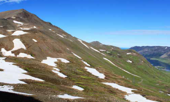
Héðinsfjörður
Göngutími: 10-14 klst.
Til Héðinsfjarðarliggja tvær leiðir fótgangandi manna frá Siglufirði: Hólsskarð(620 m) austur af Hólsdalsbotni og Hestskarð austur af Skútudal. Þótt Hestskarð (590 m) sé bratt og allerfitt yfirferðar þá er það stysta leiðin til Héðinsfjarðar og sú sem flestir fara enn þann dag í dag.
Héðinsfjörður er nokkuð styttri en Siglufjörður (að innsta fjörukambi). Stórt samnefnt stöðuvatn um 2,5 km á lengd er skammt ofan við sjávarkamb.
Í byrjun 20. aldar bjuggu í Héðinsfirði um 50 manns á 5 bæjum. Vík nyrst, þá Vatnsendi, Grundarkot, Möðruvellir og Ámá. Mjög snjóþungt er þar flesta vetur og ógnuðu snjóflóð löngum búsetu manna á þessum slóðum. Vaxandi atvinnulíf og öruggari afkomumöguleikar á Siglufirði og öðrum þéttbýlisstöðum leiddu til þess að Héðinsfjörður lagðist í eyði, síðustu Héðinsfirðingarnir fluttu í burtu árið 1951. Í Vík er nú björgunarsveitarskýli.
Silungsveiði og gott berjaland dregur fólk þangað hvert sumar og víst er að Héðinsfjörður er mjög fagur á góðum degi og hin einstæða ásýnd eyðifjarðarins lætur engan ósnortinn. Um nöfn fjalla og hæð þeirra skal vísað til landakorts.
Mesta flugslys á Íslandi varð við Héðinsfjörð 1947. Þá flaug Dakota flugvél Flugfélags Íslands í þokuveðri á Hestfjall(5) (586 m) yst við fjörðinn vestanverðan og 25 menn fórust.
Margar leiðir er að velja þegar haldið er frá Héðinsfirði. Leiðirnar Til Siglufjarðar voru nefndar fyrr. Um þrjár fjallaleiðir er að ræða ef ganga á til Ólafsfjarðar, allar um og yfir 600 m háar: Um Víkurdal, um Rauðuskörð (570 m) og niður Árdal. Um Möðruvallaskál (690 m), svokallaðar Fossabrekkur niður í Syðriárdal. Og að síðustu yfir Möðruvallaháls (650 m) fremst í Héðinsfirði og niður í Skeggjabrekkudal. Af þessari leið er hægt að fara um Sandskarð niður í Fljót.
Að síðustu skal nefnd sú leið sem flestir ættu að fara sé þess nokkur kostur en það er sjóleiðin. Hún er afar skemmtileg í góðu veðri sérstaklega ef siglt er nálægt Hestinum eða Hvanndalabjargi.
Gönguleiðir úr Ólafsfirði
Hvanndalir úr Ólafsfirði
Vegalengd: 9-10 km
Leið: Sýrdalur – Selskál - Hvanndalir.
Mesta hæð: 650 m Göngutími 6 – 7 klst.
Hrikabjörgin vestan Ólafsfjarðar eru mjög tilkomumikil að sjá þegar farið er veginn um Ólafsfjarðarmúla.
Gengið er frá Kleifum við Ólafsfjörð, farið eftir sjávarbökkum og kindaslóðum fylgt í hlíðum Arnfinnsfjalls (853 m). Ólafsfirðingar nefna Arnfinnsfjall oft Finnurinn. Víða eru gil á leiðinni sem eru þó vel greiðfær. Gengið er um land sem er vel gróið af lyngi og fjalldrapa og í sumum giljum er hann í verulegu magni, lágvaxinn en gróskumikill og hefur vaxið talsvert eftir að sauðfé fækkaði. Eftir rúmlega klukkutíma göngu er komið í mynni Fossdals (66°07,373‘-18°37,294), þar er viti á Sauðhólsmel.
Fossdalur er lítill dalur umlukinn háum hamrabeltum á þrjá vegu og gnæfir Hvanndalsbjarg (755 m) þar yfir. Eftir dalnum rennur á og steypist fram af bjargbrúninni í sjó fram og ber dalurinn nafn af þessum fossi, sem sjómenn nota gjarnan sem mið úti fyrir Ólafsfirði.
Göngubrú er á ánni enda er hún oft vatnsmikil vegna snjóþunga sem er í dalnum á vetrum. Við brúnna má finna gestabók.
Dalurinn er hömrum girtur og mætti halda að hann sé ógengur en svo er ekki því ganga má til Hvanndala og er um tvær leiðir að ræða. Önnur kölluð Stuttleið og er þá gengið á brúnum Hvanndalabjargs en Langaleið er farin um Vestaravik inn um dalbotn. Stuttleið er mjög erfið og varasöm og beinlínis hættuleg ef ekki er farið með gát.
Ef Stuttleið er valin er gengið upp á Hvanndalabjargið og farið upp frá brúnni yfir ána og stefnan tekin upp bratta hlíðina. Hækkunin er 500 m, leiðin er ekki ýkja erfið en gott er að halda sig vel frá bjargbrúninni. Yfir hábrún Bjargsins gengur hlíðarflái (nefndur Flagið) vestur yfir á brún Sýrdals. Upptök Flaggjárinnar er hér en hún nær 600 m niður í sjó og er best að halda sig frá henni. Aðeins ein leið er fær um klettaskoru af hábjarginu niður í Sýrdal. Upphaf hennar (N66°8,021‘-V18°38,402‘) að ofanverðu er mjög framarlega á Sýrdalsbrún, þ.e. nálægt brún hábjargsins yfir sjó, stöng er þar sem farið er niður. Skoran er mjög brött fyrstu 100 metrana. Gjáin nær um 200 m í gegnum hamrahlíðina og stefnir ofurlítið inn á við. Niður gjánna verður að fara með gætni. Þegar niður í Sýrdalinn er komið þarf að velja ysta skarðið í Hádegisfjallinu. Aðeins er fært á einum stað, um smáskarð í brúninni (N66°8,538‘-V18°39,013‘). Ekki er auðþekkt að finna það rétta neðan frá séð. Í skarðinu er manngerð grjóthleðsla, snarbrött skriða er úr skaðinu niður í Seldal. Úr Selskál opnast svo megindalur Hvanndala. Langaleið liggur inn í botn Fossdals og þaðan er gengið upp hlíðina að skarði ofan í Austaravik og þaðan liggur leiðin í Hvanndali. Í Hvanndölum er staður sem heitir Ódáinsakur. Þar voru talin vaxa lífgrös og sá sem þeirra neytti gat ekki dáið. Stóð áður bær hjá Ódáinsakri en hann lagðist í auðn og var fluttur á annan stað vegna þess að menn töldu seig ekki geta búið við slík örlög.
Múlakolla
Vegalengd: 4.0 km (önnur leiðin)
Leið: Brimnesá – Gvendarskál – Múlakolla.
Mesta hæð: 970 m
Göngutími 4 – 5 klst. (Báðar leiðir)
Er við nálgumst kaupstaðinn opnast fjörðurinn betur og þegar komið er heim undir á, sem ber nafnið Brimnesá, er á vinstri hönd gönguleið sem ekki margir fara, en það er ganga á hæsta hluta Múlans sem nefnist Múlakolla í 984 m. hæð. Ekki verður sagt að þessi leið sé vandrötuð en halda má sem leið liggur upp fjallið og stöðugt blasir kollan við. Besta leiðin er að ganga beint upp frá veginum upp norðan við Brimnesá.
Á hægri hönd er nú Brimnesdalur stuttur og hrjóstrugur, umlukinn fjöllum sem mörg eru yfir 1000 m. Á hægri hönd er Tindaöxl en svo nefnist fjallið ofan við Ólafsfjarðarkaupstað, og fyrir dalbotninum eitt hæsta fjall Ólafsfjarðar, Kerahnjúkur sem skagar upp í 1098 m. Af tindi Kerahnjúks er stórfenglegt útsýni en ekki ætti nema vant fjallafólk að klífa tindinn. Gengið er á Kerahnjúk upp frá kaupstaðnum og fyrst upp á Tindaöxl. En áfram skal haldið á Múlakollu, þá mætir okkur allbrattur hjalli vel gróinn og þegar upp á hann er komið er gott að staldra við því gott útsýni er af brúninni yfir Ólafsfjörð.
Fyrir ofan þessa brún tekur við ofurlítil lægð. Oft eru þarna vatnspollar sem hitna af sólarljósinu og voru þeir vinsælir af unglingum sem gjarnan fóru þangað í útilegur á sumrin. Við erum nú í litlu dalverpi, á vinstri hönd er Múlinn og á hægri hönd er Kistufell, 1078 m. Við göngum þannig að við höldum okkur hægramegin og nær Kistufelli.
Framundan er nú brattasti hluti leiðarinnar upp í skál sem nefnist Gvendarskál; skál þessi er oftast full af snjó. Þegar gengið er upp í Gvendarskál er hægt að velja um tvær leiðir. Önnur er sú að ganga beint upp brattann en hann er mjög laus í sér og stórgrýttur, enda féllu þarna stórar skriður haustið 1988 og runnu alveg í sjó fram. Auðveldari leið er að fara hægramegin við skriðuna og ganga á snjó upp í Gvendarskál, sú leið er greiðfær. Þegar brúnum skálarinnar er náð er gengið eftir ölduhryggjum til norðausturs í áttina að Múlakollu og er þessi hluti leiðarinnar mjög auðveldur göngu.
Af Múlakollu er útsýni stórkostlegt og sést vítt um fjöll og dali. Fyrir fótum okkar liggja Ólafsfjörður og Eyjafjörður; ef skyggni er gott má sjá reykina á Námaskarði liðast til himins.
Efst á Múlakollu hefur einkaaðili í Ólafsfirði reist endurvarpsstöð sem tekur við sjónvarpssendingum að sunnan. Ganga má frá endurvarpsstöðinni í átt að Kistufelli og eftir eggjum Kistufells. Á Múlakollu er um tveggja til tveggja og hálfs tíma gangur en vanir fjallamenn ganga upp á einum og hálfum tíma.
Kerahnjúkur
Vegalengd: 4,50 km (önnur leiðin)
Leið: Hornbrekka – Hornbrekufjall - Kerahnjúkur.
Mesta hæð: 1097 m
Göngutími 5 – 6 klst. (Báðar leiðir)
Þegar gengið er á Kerahnjúk er gott að leggja upp frá skíðaskálanum í Ólafsfirði og taka stefnuna sunnan lyftu í átt að syðsta hluta klettabeltisins sem er í Hornbrekkufjalli beint upp af Hornbrekku. Þegar komið er upp á brún Hornbrekkufjalls sér í tindinn, sem skagar til himins mikilúðlegur og krefjandi. Gengið er með brúnum og er Brimnesdalur á vinstri hönd. Nokkuð löng leið er á tindinn sjálfan og er fremur bratt efst. Á toppi Kerans er varða og ægifagurt útsýni til allra átta. Gott er einnig að ganga á Kerahnjúk austan frá, er þá lagt upp frá þjóðveginum sunnan Sauðár og gengið fram Sauðdal sem er þægilegur yfirferðar. Þegar komið er fram í botn dalsins er best að stefna í skarðið milli Bassa og Kerahnjúks og þegar upp í það er komið skal fylgja fjallsröðinni á toppinn.
Hreppsendasúlur
Vegalengd: 3 km (önnur leiðin)
Leið: Lágheiði - Hreppsendasúlur.
Mesta hæð: 1052 m
Göngutími 3 – 5 klst. (Báðar leiðir)
Ekki er svo hægt að fjalla um Lágheiði að ekki sé minnst á gönguleið á Hreppsendasúlur. Fjall þetta rís upp af Lágheiðinni í vesturátt, hátt og tignarlegt og frá Ólafsfjarðarkaupstað ber tvær súlur þess við himin og sjómenn nota fjallið mjög mikið sem staðsetningarmerki á fiskimið þegar verið er á veiðum úti af Ólafsfirði og er þá talað um að vera uppi á Súlum.
Súlurnar eru um 1052 m. háar og þegar gengið er á þær má velja um margar leiðir en sú besta er að ganga frá norðri eftir fjallsrana sem gengur út í áttina að Ólafsfjarðarkaupstað. Ágætt er að fara upp með Hreppsendaá að sunnan og ganga þannig í áttina að fjallinu. Land er þar mjög vel gróið sem annarstaðar á heiðinni. Þegar komið er upp að fjallinu er best að koma sér upp á fjallsöxlina og fylgja henni. Leiðin er ágætlega greiðfær og eftir því sem ofar dregur opnast útsýnið betur, við blasa austurfjöllin og Reykjaheiði, Klaufabrekknadalur og allur Ólafsfjörður. Þegar gengið er eftir fjallsegginni er gott útsýni yfir Hreppsendaárdal, lítið dalverpi skállaga og er auðveld leið upp dalinn og yfir í Fljót. Eftir um tveggja stunda gang er staðið á vestari súlunni en þar er varða og þaðan er útsýni undrafagurt.
Fljótin liggja fyrir fótum okkar og sér niður á bæina Þrasastaði (fremsta bæ í Fljótum) og Depla, einnig sést Stífluvatn með Skeiðsfossvirkjun. Niður við sjó sér í Miklavatn og í fjarska Haganesvík. Fjallasýn til allra átta er líka stórfengleg og vel sést hrikaleiki fjallgarðsins. Og ef vel er að gáð sjást fjöllin austanmegin í Svarfaðardal: Kotafjall, Skeiðsfjall, Búrfellshyrna og fleiri.
Hvanndalabjarg - Hvanndalir
Hvanndalir
Hrikabjörgin vestan Ólafsfjarðar eru mjög tilkomumikil að sjá þegar farið er veginn um Ólafsfjarðarmúla. Þar heita þau hæstu Arnfinnsfjall (854 m) og Hvanndalabjörg (755 m), þverhnípt standberg í sjó fram vestan við Ólafsfjörð, en að austan "teygir hinn myrki múli fram, minnist við boðaföllin" eins og prófessor Jón Helgason orðaði það. Norðan undir Hvanndalabjargi eru Hvanndalir og norðan þeirra Hvanndalabyrða (625 m) og Hvanndalaskriður sæbrattar en þó færar fyrir gangandi menn við góð skilyrði. Háir sjávarbakkar eru fram undan dölunum, tæpar lendingar og uppsátur örðugt. Um Víkurbyrðu, sem liggur bak við eða vestan við Hvanndali, er leið yfir í Héðinsfjörð til Víkurdals.
Hvanndalir eru þrjú daladrög. Yst er Hvanndalur, út úr honum að sunnan er lítið dalhvolf sem nefnt er Selskál og syðst Sýrdalur sem er grynnstur, aðeins slakki niður á bak við Hvanndalabjörg. Milli Sýrdals og Hvanndals er lágur fjallsrani sem heitir Hádegisfjall og sunnan við Selskál gnæfir hvassbrýndur hamratindur sem heitir Miðdegisfjall eða Miðdegishyrna.
Hádegisfjall er nyrsti hluti Hvanndalabjargs. Vestast í því við efri enda Sýrdals er lítil gjá eða einskonar hlið sem farið er um úr aðaldalnum. Þar var fyrir óralöngu gerður lítill grjótgarður sem lokaði alveg fyrir þennan hömrum girta dal. Þar voru áður fyrr meðan ennþá var byggð í Hvanndölum geymd fráfærnalömbin og var þetta því einskonar afréttur og litli grjótgarðurinn einskonar afréttargirðing, líklega sú stysta á landinu. Í Jarðabók Árna og Páls segir um Hvanndali að nokkrir segi "það hafi að fornu heitið Fanndalir". Inni í slíkum fjallasal safnast miklar fannir að vetri til en fram á bökkunum var snjólétt og þarna eru annáluð landgæði fyrir sauðfé.
Í Hvanndölum er staður sem heitir Ódáinsakur. Þar voru talin vaxa lífgrös og sá sem þeirra neytti gat ekki dáið. Stóð áður bær hjá Ódáinsakri en hann lagðist í auðn og var fluttur á annan stað vegna þess að menn töldu seig ekki geta búið við slík örlög.
Hvanndalir eru mjög einangraður útkjálki. Stopul byggð var þar og flestir sem þar bjuggu voru aðeins fá ár í senn. Var því býli þetta oft í eyði svo árum og áratugum skipti. Árið 1896 keypti hreppsnefnd Hvanneyrarhrepps jörð þessa af bóndanum í Hvanndölum til þess að útiloka mannabyggð þar. Um áratug síðar var jörðin seld bónda í Ólafsfirði. Fyrr á árum notuðu Ólafsfirðingar Hvanndali til heyskapar og var þá legið þar við í tjöldum á meðan á heyskap stóð. Erfitt hefur sennilega oft verið að flytja heyið þaðan en þarna er ákaflega grösugt.
Þar sem Hvanndalir eru fyrir opnu hafi og háir klettabakkar eru framundan þeim er hætta á sjóslysum þar þegar veður breytist snögglega. Enda hafa slys orðið þar, bæði við setningu og lendingu báta. Átakanlegt sjóslys varð í svokölluðum Sýrdalsvogum árið 1783 er þrír bátar fórust þar og af þeim ellefu sjómenn. Var það vegna skyndilegs ofveðurs sem skall á er þeir voru við veiðar undir bjarginu. Þarna er mjög brimasamt ef eitthvað er að veðri. Nú er í Hvanndölum björgunarskýli Slysavarnafélags Íslands, þeim til bjargar sem lenda í hrakningum þarna svo langt frá mannabyggðum.
Hvanndalabjörg
Af hamrafjöllum Hvanndala er víð útsýn austur með Norðurlandi, alla leið til Melrakkasléttu, og Látraströnd austan Eyjafjarðar blasir við. Til norðurs sér út yfir Grímseyjarsund og til Grímseyjar. Inn til landsins taka við óreglulegar fjallastrýtur og klettahryggir með hjarnfönnum. Er þetta allt hið hrikalegasta landslag sem virðist vera ógreiðfært í hæsta máta og ekki árennilegt, og varla öðrum fært en fuglinum fljúgandi eins og sagt var í ævintýrunum. Eitthvað verða menn þó að fara um þetta svæði vegna fjárleita.
Í Hvanndalabjörgum er sagt að sé mikil tröllabyggð:
Rísa þar gegn norðrinu risalegfjöll.
Hvergi eru meiri og magnaðri tröll.
Svo segir Jón Trausti í kvæðinu Konan í Hvanndalabjörgum sem hann orti eftir þjóðsögu um konu er hvarf í Hvanndalabjörg frá bónda sínum í Málmey á Skagafirði. Saga þessi er til í fleiri en einni gerð, en hér verður rifjað upp aðalefni sögunnar í þeirri gerð sem skáldið notar.
Maður konunnar hét Jón, bjuggu þau í Málmey og hvarf konan frá honum aðfararkvöld jóla. Leitaði þá Jón bóndi til prests síns, séra Hálfdanar Narfasonar (d. 1568) á Felli í Sléttuhlíð, til þess að hafa uppi á konunni. Varð úr að séra Hálfdan reið láð og lög með Jón bónda fyrir aftan sig og segir svo frá för þeirra í Þjóðsögum Jóns Árnasonar:
Nú halda þeir áfram fyrir framan Siglufjörð og Siglunes og svo fyrir framan Héðinsfjörð, uns þeir koma að Hvanndalabjargi vestan við Ólafsfjörð. Þar nemur prestur loks staðar framan undir bjarginu. Er þar að sjá einsog stór hurð í bjarginu; lýkst hún upp og koma þar út tvær tröllkonur, mjög stórar og allar helbláar; leiða þær milli sín þriðju tröllkonuna, sem er nokkru minni, en öll líka helblá, nema hvítur kross í enni. . . . "Þarna sérðu konuna þína, Jón," segir prestur. (III. S. 534-535)
Í Hvanndölum voru bræður þrír á dögum Guðbrands biskups Þorlákssonar. Þeir voru "knálegir menn, og kunnu vel til á sjó, sterkir og hugaðir vel" einsog segir í Árbókum Espólíns. Biskupinn fékk þá árið 1580 til að leita Kolbeinseyjar því hann taldi að einhverjar nytjar mætti af henni hafa. Frá för þeirra Hvanndalabræðra segir í Kolbeinseyjarvísum sem séra Jón Einarsson orti 1665 og prentaðar eru í ritinu Blöndu (I). Bræðurnir komust til Kolbeinseyjar í þriðju tilraun, fermdu skip sitt af fiski, eggjum og fugli; höfðu með sér til biskups langvíu, geirfugl og fýl.
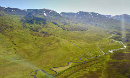
Skeggjabrekkudalur
Skeggjabrekkudalur er nokkuð langur; hann liggur frá norðaustri til suðvesturs. Dalurinn er mjög grösugur og eitt allra vinsælasta útivistarsvæði Ólafsfirðinga, enda var hann gerður að friðlýstum fólkvangi 1984 í tilefni af hundrað ára byggð í Horninu, en þar stendur kaupstaðurinn nú. Dalurinn er gróinn víða upp á fjallstoppa. Mest ber á allskonar lynggróðri í neðanverðum dalnum og einstaka birkihrísla sést, en vegna snjóþunga skríður þessi gróður með jörðu. Berjaspretta er oft góð í dalnum og þá aðallega aðalbláber og krækiber og sækir fólk mikið þangað til útiveru, enda eru gönguleiðir um dalinn auðveldar.
Raunar skiptist dalurinn í tvennt og er sá hluti sem er vestan við á kallaður Skeggjabrekkudalur en austurhlutinn Garðsdalur. Tveir sveitarbæir standa hvor sínumegin við ána rétt áður en hún fellur í Ólafsfjarðarvatn; heitir sá sem er norðan við ána Skeggjabrekka og stendur á hól sem blasir við frá kaupstaðnum. Þar er mjög fagurt útsýni á góðviðrisdögum. Í landi Skeggjabrekku er nú golfvöllur Ólafsfirðinga. Sunnan við ána stendur bærinn Garður og er áin við hann kennd. Garðsá var virkjuð árið 1942 og var lengivel eina raforkuverið sem veitti Ólafsfirðingum orku, en með tilkomu Skeiðfossvirkjunar í Fljótum var lögð lína yfir Lágheiði og síðar með hringtengingu landsins um Dranga frá Dalvík. Virkjunin var í eigu Ólafsfjarðarkaupstaðar en síðar seld Rafmagnsveitum ríkisins sem nú starfrækja hana.
Árið 1944 er ráðist í það stórvirki að bora eftir heitu vatni en á Skeggjabrekkudal voru heitar lindir. Tilraunin gekk vel og nægt vatn fékkst til að hita upp öll hús á Ólafsfirði og mun Ólafsfjörður vera fyrsti kaupstaður á landinu þar sem öll hús voru hituð upp með jarðvarma. Dugði þetta fram til ársins 1974 er ný hola var tekin í notkun í Ósbrekkulandi um hálfan kílómeter frá kaupstaðnum. Dalurinn afmarkast af Ósbrekkufjalli að vestan og Garðshyrnu að austan. Dalurinn blasir allur við frá Ólafsfjarðarkaupstað. Um miðjan dalinn hefur skriðufall stíflað hann en áin síðan brotið sér leið í gegn. Skriða þessi er í daglegu tali nefnd Hólar. Þegar komið er fram fyrir Hóla er oft mikil veðursæld. Hólarnir skýla vel fyrir hafgolunni sem er iðulega mikil á heitum dögum og þar er því oft logn og hiti á sólríkum dögum og er þar graslendi nokkurt.
Á vetrum er dalurinn sannkölluð paradís fyrir gönguskíðafólk og þegar sól hækkar á lofti er oft margt um manninn á dalnum. Þá er hann mikið farinn af vélsleðamönnum, enda auðveld leið hvort heldur er í Héðinsfjörð eða Siglufjörð.
Ólafsfjarðarskarð
Vegalengd: 15-16 km
Leið: Þverá – Kvíabekkjardalur – Ólafsfjarðarskarð – Ólafsfjarðardalur – Brúnastaðir í Fljótum.
Mesta hæð: 740 m.
Göngutími: 6-7 klst
Ólafsfjarðarskarð er í fjallgarðinum milli Ólafsfjarðar og Fljóta og var ein af aðalleiðum landpóstanna sem fóru frá Akureyri um Ólafsfjörð til Siglufjarðar.
Leiðin liggur upp frá landnámsjörðinni Kvíabekk, þó hefur í seinni tíð verið farið upp frá Þverá, næsta bæ sunnan við Kvíabekk, en þar er nú vegarslóði upp á dalinn. Leiðin liggur um Kvíabekkjardal upp með Þverá en svo heitir áin sem rennur um dalinn og sameinast Ólafsfjarðará.
Kvíabekkjardalur er mjög grösugur enda voru í mynni hans mörg smábýli sem öll eru nú horfin og eftir standa tóftir einar. Til suðvesturs gengur dalur sem ber nafnið Húngilsdalur og rennur Þverá eftir honum. Fremri hluti Kvíabekkjardals nefnist Skarðsdalur og ber hann nafn af skarði því sem við förum í gegnum og áður er nefnt.
Þegar komið er upp í mynni dalsins skiptir Þveráin sér og höldum við okkur við ána sem rennur eftir Skarðsdal. Ólafsfjarðarskarð blasir nú við, 743 m., með fjöllum á hvora hönd sem ná upp í tæplega 900 m. Leiðin fram Skarðsdal er mjög greiðfær hvort heldur er lausfóta, eins og Ólafsfirðingar segja, eða á skíðum, en erfitt getur reynst að fara um skarðið á vélsleðum þar sem síðasta brekkan er mjög brött.
Þegar staðið er í skarðinu sér vel niður í Fljótin og niður að Miklavatni. Úr skarðinu er orðið mjög stutt yfir í Héðinsfjörð og ef gengið er í hlíðum fjallsins til hægri Fljótamegin er komið í Sandskarð sem er fjölfarin leið úr Fljótum til Ólafsfjarðar og Héðinsfjarðar (sjá um Skeggjabrekkudal hér á eftir).
Niður Ólafsfjarðardal Fljótamegin er greiðfært og sér niður að Ketilási sem er félagsheimili þeirra Fljótamanna.
Burstabrekkudalur / Drangar
Lagt er upp frá Burstabrekku þegar gengið er til Dalvíkur um Dranga. Bærinn Burstabrekka er um einn og hálfan km. sunnan Ólafsfjarðarkaupstaðar. Leið þessi er auðrötuð vegna þess að raflína var lögð um Dranga frá Dalvík og er næstum hægt að fylgja línunni alla leið.
Þegar gegnið er upp frá Burstabrekku er fylgt vegarslóða sem myndaðist þegar raflínan var lögð. Leiðin er létt, gengið er yfir gróið land og bratti lítill. Burstabrekkudalur er sem aðrir dalir hér um slóðir umlukinn háum fjöllum. Á hægri hönd er Hólkotshyrna, 895 m., ákaflega svipmikið fjall sem gnæfir yfir, séð frá Ólafsfjarðarkaupstað sem píramíti. Á vinstri hönd er mikill fjallgarður sem gengur frá Kerahnjúk að norðan inn að Dröngum að sunnan, óslitin fjallsegg sem nær hæst 1062 m. hæð.
Burstabrekkudalur er nokkuð gróinn upp í miðjan dal en þá tekur við gróðurlítið svæði enda liggur snjór oft yfir dalnum langt fram á sumar. Í miðjum dal er lítið stöðuvatn og er afrennsli þess Burstabrekkuá, allmikil á miðað við hve stutt hún er. Á vorin ber hún með sér mikið af malarbornu efni niður undir Ólafsfjarðarvatn, þar er það tekið og notað til ofaníburðar í vegi.
Dalurinn er sem áður er sagt umlukinn háum fjöllum og með þverhníptum klettabeltum og er sú hlið Hólkotshyrnu sem inn í dalinn snýr nær ókleif. Er upp í dalinn er komið blasir við skarðið sem nefnt er Drangaskarð. Gangan fram dalinn er auðveld, farið er enn eftir vegarslóða um melöldur. Brátt tekur við síðasti spölurinn upp í skarðið og er gengið á snjó. Brekkan er brött en auðveld uppgöngu og brátt er staðið í skarðinu. Útsýni er fallegt til Ólafsfjarðar og sést hluti fjarðarins í vaffinu sem dalurinn myndar.
Úr skarðinu sér niður í Karlsárdal og er nokkuð bratt niður úr skarðinu og ættu menn að fara þar með gát. Þá sér út á Eyjafjörð. Karlsárdalur er nokkuð langur, svo ætla má að ferðin í heild niður á þjóðveg taki um þrjár til fjórar stundir. Þessa leið er mjög gaman að fara á skíðum og tekur hún þá mun styttri tíma ef færi er gott. Þar sem snjóalög eru mikil í dalnum eru snjóflóð tíð og ber að varast að fara mikið um dalinn ef hætta er á snjóflóðum. Einnig er mjög varasamt að fara upp í Drangaskarð um hávetur, en þá er oft svo lágt undir háspennulínur að hætta stafar af. Á Burstabrekkudal eru lindir þær er sjá Ólafsfjarðarkaupstað fyrir köldu vatni.
Sumarskíðasvæði er líka ágætt á Burstabrekkudal og er talað um að koma upp aðstöðu fyrir skíðafólk enda var dalurinn á árum áður mikið notaður til skíðaferða þegar lítill snjór var í byggð.
Leiðin um Dranga var mjög fjölfarin áður fyrr; ekki er þó hægt að fara um skarðið á hestum sökum þess hve bratt er Dalvíkurmegin. Leiðin var mikið farin þegar sækja þurfti lækni eða lyf og var talin auðveld bæði að sumri og vetri. Nú er leiðin nokkuð farin af ferðafólki, bæði frá Dalvík og Ólafsfirði.
Grímubrekkur
Lagt er upp frá Burstabrekku þegar gengið er til Dalvíkur um Dranga. Bærinn Burstabrekka
Vegalengd: 13-14 km
Leið: Kálfárdalur – Grímubrekkur – Grímudalur – Upsadalur - Dalvík.
Mesta hæð: 930 m.
Göngutími: 6-8 klst.
Þegar valdar voru gönguleiðir milli Ólafsfjarðar og Dalvíkur var að sjálfsögðu valin sú leið sem næst var þeim stað sem leggja skyldi upp frá. Ef farið var úr kaupstaðnum var Drangaleið valin, úr miðsveitinni var valið að fara Grímubrekkur og ef upphafsstaður var framsveitin varð Reykjaheiði fyrir valinu. En eina leiðin sem fær er hestum er þó Reykjaheiði. Þegar lagt er á Grímubrekkur er haldið upp frá bænum Kálfsá og gengið fram Kálfsárdal og komið niður í Grímudal sem er upp af Upsadal vestan Dalvíkur.
Leiðin yfir Grímubrekkur er mjög skemmtileg gönguleið, greiðfær þó að á nokkrum stöðum sé nokkuð bratt. Sem áður segir er gengið upp frá Kálfsá. Kálfsárdalur er lítið dalverpi sem gengur til suðurs og afmarkast hann af Nítuhnjúk, 955 m., og Lágafjalli að norðan og Hólshyrnu, 853 m. (líka nefnd Kálfsárhyrna), að sunnan. Á milli Nítuhnjúks og Lágafells er skál er nefnist Egilsskál en líka nefnd Kálfsárskál. Hólshyrna er eitt fegursta fjall í Ólafsfirði, hefur reglulega lögun, rís hátt og bratt upp af bæjunum Kálfsá, Kálfsárkoti og Hóli og setur mikinn svip á sveitina.
Fyrsti spölurinn upp frá Kálfsá er greiðfær og auðvelt er að rata þessa leið í björtu veðri, en eins og á öðrum leiðum í Ólafsfirði getur þar verið villugjarnt ef þoka hamlar sýn. Símalína var lögð um Grímubrekkur 1908 og sér enn fyrir vegarslóðum sem myndast höfðu er vinnuflokkar önnuðust viðgerðir á línunni. Línan er nú aflögð því með tilkomu Múlavegar var lagður sími þar. Enn sjást þó staurabrot sem minna á þessa lögn.
Gengið er upp með ánni að sunnan. Nokkrir fossar eru í henni og heitir sá fyrsti Stórifoss og þar upp af Litlifoss. Þegar komið er upp í dalsmynnið heitir Kálfsárháls, en hann nær frá Hólshyrnu (Kálfsárhyrnu) norður að ánni. Áður nefndur Kálfsárdalur ber raunar tvö nöfn, hann er nefndur Norðurdalur norðan árinnar en Suðurdalur sunnan hennar. Nokkurt graslendi er í dalnum og þá aðallega á afmörkuðum stöðum. Rétt framan við Kálfsárháls er Ystanef, nokkuð stórt grasigróið nef sem skagar út í ána, þar framan við er Fremstanef og milli þeirra Laugarhvammur en þar eru volgar uppsprettur. Syðst í Hólshyrnu eru grasigrónir hjallar er nefnast Grænuhjallar. Framarlega í dalnum tekur við stór háls er nær þvert yfir dalinn og nefnist hann Hávaði.
Er komið er upp á Hávaðann blasir skarðið við. Framundan er lítið vatn, Kálfsárdalsvatn, þar sem Kálfsá á upptök sín en í dalbotninum er lítill jökull. Á vinstri hönd er Bræðraleið en á hægri hönd Þröskuldur. Þegar farin er Bræðraleið er komið niður í Karlsárdal norðan við Dalvík, en ef farinn er Þröskuldur er farið niður að Hóli í Ólafsfirði og völdu menn þessa leið þegar komið var frá Dalvík ef fara átti fram í fjörðinn.
Er við göngum í átt að Grímubrekkum er á vinstri hönd gríðarstór skriða sem fallið hefur fram í dalinn og eru steinarnir í henni margir hverjir mörg tonn. Halda skal fram fyrir þessa skriðu og taka stefnu upp í skarðið. Bratt er síðasta spölinn. Staurabrot eru í skarðinu. Á hægri hönd er Einstakafjall, 1006 m., en sunnan við það er Reykjaheiði. Úr skarðinu sér út á Eyjafjörð í átt til Hríseyjar. Hægt er að ganga eftir eggjum í átt að Dröngum og er það skemmtileg gönguleið og er þá komið niður í Burstabrekkudal. Leiðin til Dalvíkur er greiðfær, að vísu er nokkuð bratt niður úr skarðinu en fljótlega komið í grónar hlíðar. Gangan tekur um fjóra til fimm tíma.
Reykjaheiði
Reykjaheiði var á fyrri öldum einn algengasti og fjölfarnasti fjallvegur milli Svarfaðardals og Ólafsfjarðar vegna þess að þetta er eina leiðin sem er vel fær hestum. Leiðin var fljótlega vörðuð og fyrir nokkrum árum fóru hestamenn í hestamannafélaginu Gnýfara í Ólafsfirði og endurreistu vörðurnar Ólafsfjarðarmegin, fyrir bragðið er nú leiðin auðrataðri.
Yfir Reykjaheiði fór pósturinn á leið sinni til Ólafsfjarðar, Fljóta og Siglufjarðar. Fé Svarfdælinga leitaði áður fyrr mjög yfir í gósenlönd Ólafsfjarðar því alla tíð hefur þar verið gott til beitar fyrir sauðfé. Úrtíningsmenn úr Svarfaðardal fóru yfir á Reykjarétt fremst í Ólafsfirði og í Stíflurétt í Fljótum og ráku féð til baka yfir Reykjaheiði.
Leiðin yfir Reykjaheiði er lengsta leiðin af þeim sem farnar eru milli Ólafsfjarðar og Svarfaðardals, ef frá er talin leiðin um Klaufabrekknaskarð. Lagt er upp frá eyðijörðinni Reykjum en þar eru heitar lindir. Búið var að Reykjum fram til 1940. Ungmennafélagið í firðinum byggði sundlaug hlaðna úr torfi og grjóti og var hún notuð til sundkennslu allt fram að þeim tíma að sundlaug var byggð niðri í Ólafsfirði. Þarna er nú sumarbústaðahverfi og nota eigendur þeirra heita vatnið sem þar næst með góðu móti. Sunnan við Reyki er Reykjaá og í henni foss sem ber nafnið Reykjafoss, mikill úði er oft frá fossi þessum og sést langar leiðir.
Þegar lagt er á heiðina er farið frá þessum sumarhúsum. Norðan við Reyki er á er nefnist Lambá og er farið upp með henni að sunnan. Í fyrstu er farið yfir gróið land og ber þar mest á ýmiskonar lyngi, sem annarstaðar í Ólafsfirði, enda eru ágæt berjalönd í firðinum. Brátt rekumst við á fyrstu vörðurnar á leið okkar. Þær eru reistar á melum, en leiðin sem farin er getur varla talist mikið augnayndi, melar og aftur melar er það sem um er farið og snjór í lautum fram eftir öllu sumri. Leiðin getur varla kallast brött, melarnir eru þræddir og eftir tveggja stunda göngu er komið í skarðið sem er í rúmlega 800 m. hæð. Til vinstri handar er Einstakafjall og norðanmegin við það fjall eru Grímubrekkur þannig að stutt er á milli þessara fjallvega. Þegar horft er til Ólafsfjarðar sjást bæirnir Hreppsendaá, sem er í eyði, og Bakki en þar er nú stærsta fjárbú í Ólafsfirði. Leiðin til Dalvíkur er nú greið en nokkuð er bratt niður úr skarðinu Dalvíkurmegin en samt ágæt leið og auðfarin. Síðan liggur leiðin eftir Upsadal eða Böggvisstaðardal. Þessi leið er nú á dögum aðallega farin af ríðandi mönnum.
Rauðskörð
Vegalengd: 10 km
Leið: Kleifar - Rauðskarðsdalur.
Mesta hæð: 570 m.
Göngutími: 5-6 klst.
Gönguleiðin um Rauðskarð er sú leið sem mest er farin úr Ólafsfirði og koma margir ferðamenn nú hvert sumar, bæði innlendir og erlendir, og leggja upp frá Kleifum eða koma til Kleifa úr Héðinsfirði og mjög algengt er líka að Héðinsfjörður sé aðeins viðkomustaður á leið ferðamanna frá Siglufirði eða Ólafsfirði.
Þegar gengin eru Rauðskörð (Ólafsfirðingar nefna þau svo) er lagt upp norðan Gunnólfsár, upp frá Ytri-Á. Dalurinn er mjög auðveldur uppgöngu og vel gróinn. Lítill bratti er á leiðinni þar til kemur fram þar sem lagt er á skarðið. Gengið er undir hlíðum Arnfinnsfjalls í fyrstu, en þegar kemur fram í miðjan dal er stór skál í fjallið er nefnist Hrafnaskál og við tekur Ytrárfjall. Úr Hrafnaskál gengur allstórt gil og þar fyrir framan eru hjallar er nefnast Jókuhjallar. Þar er mjög góð skíðastökkbraut frá náttúrunnar hendi og hafa ólafsfirskir stökkvarar oft notað hana þegar lítill snjór er í byggð. Þegar komið er vel inn fyrir Jókuhjalla eru Rauðskörð á hægri hönd, tvö skörð eru í fjallseggina og er Rauðskarð fremra og hærra skarðið, en skarðið nær Hrafnaskál heitir Loftskarð og ef farið er þar um er komið niður í botn Víkurdals. Sú leið er mun erfiðari en að fara Rauðskörð. Best er að fara vel inn fyrir skarðið og ganga síðan hlíðina til norðurs upp á klettahausa sem þar eru. Bratt er upp í skarðið en þó ágætt að fara ef rétt leið er farin. Þegar staðið er í skarðinu er fagurt útsýni til Kleifa og austan fjarðarins blasir Múlinn við.
Niður í Víkurdal er greiðfært og komið er fyrst niður í skál allstóra; í henni er stór steinn þar sem menn hvíla sig gjarnan. Frá steini þessum rennur lækur sem fylgja ætti þegar farið er niður úr skálinni. Gangan til Víkur í Héðinsfirði tekur um fjóra tíma.
Árdalur
Út með vestanverðum Ólafsfirði hefur orðið til lítið þorp er nefnist Kleifar. Á Kleifum eru tvö lögbýli Syðri-Á og Ytri-Á, en aðeins er nú búið á Syðri-Á. Nokkur hús eru þarna en aðeins búið í þremur þeirra í dag. Öll önnur hús eru nú notuð til sumardvalar og er þeim vel við haldið. Mjög sumarfagurt er á Kleifum og er þar oft margt um manninn á sumrum. Mjög stór ættbogi er frá Ytri-Á, en þar bjuggu síðast tveir bræður ásamt eiginkonum sínum og áttu önnur hjónin tuttugu börn en hin tíu og sækja þau mjög til átthaganna á sumrum. Bæirnir standa hvor sínumegin við á sem heitir Gunnólfsá. Þarna settist annar landnámsmaður Ólafsfjarðar að, en sá hét Gunnólfur gamli. Upp af Kleifum gengur allstór dalur er Árdalur heitir og rennur Gunnólfsá eftir honum miðjum, en er upp í dalinn kemur skiptist áin og rennur Gunnólfsá í Syðrárdal en önnur á rennur í Ytrárdal og nefnist hún Rauðskarðsá. Þar sem árnar mætast heita Tungur.
Árdalur er sem aðrir dalir Ólafsfjarðar girtur háum fjöllum. Að norðan í dalsmynninu er Arnfinnsfjall, 854 m., í daglegu tali kallað Finnurinn, og innar Ytrárfjall, 842 m., að sunnan er Ósbrekkufjall og heitir nyrsti hluti þess Syðrárhyrna, 724 m., Þverfjall, 905 m., skiptir dalnum í tvo fyrrnefnda dali, Syðrárdal sem gengur til suðvesturs og Ytrárdal sem gengur til norðvesturs.
Góðar gönguleiðir eru til Héðinsfjarðar úr Syðrárdal um Fossabrekkur og úr Ytrárdal um Rauðskarð. Þá er leið innst úr botni Ytrárdals sem nefnist Afglapaskarð en Ólafsfirðingar búsettir á Kleifum kalla skarðið Vatnsendaskarð. Leið þessi er lítið farin enda brött og verra að fara hana en hinar leiðirnar.
Fossbrekkur
Vegalengd: 11-12 km
Leið: Kleifar – Syðriárdalur – Möðruvallaarskál – Fossabrekkur - Héðinsfjörður
Mesta hæð: 680 m.
Göngutími: 7-8 klst.
Þegar farið er um Fossabrekkur er lagt upp sunnan við Gunnólfsá og upp með henni fram Syðrárdal og norðan við Syðrárhyrnu. Dalurinn allur er nokkuð á fótinn. Gengið er eftir dalnum sunnan árinnar og sem leið liggur fram í botn. Á hægri hönd þegar í dalbotninn er komið er fjallið Bangsahnjúkur, 890 m., og er nauðsynlegt að fara vel inn í botninn til að lenda ekki í skál sem nefnist Bangsaskál.
Síðasti spölurinn upp í skarðið er nokkuð brattur. Gengið er upp tvær melöldur og er sú fyrri brattari. Sveigt er til norðvesturs upp í skarðið. Þegar haldið er niður Héðinsfjarðarmegin er gengið niður allnokkurn bratta á jökli niður í svokallaða Möðruvallaskál, eftir það er greið leið niður í Héðinsfjörð. Komið er niður nokkru fyrir framan Vatn að eyðibýli sem heitir Grundarkot.
Gangan upp í skarðið frá Kleifum tekur um tvo til þrjá tíma og getur leiðin verið vandrötuð í slæmu skyggni. Mikið er um að vélsleðamenn fari þessa leið enda ekki önnur leið fær vélsleðum upp úr Árdal til Héðinsfjarðar. Niður að Grundarkoti er um fimm tíma gangur.


